
Accelerating Natural Resource Exploration with Real-Time Edge Intelligence
Inter Connect Point (ICP) combines proprietary hyper-spectral sensor arrays, edge-computed machine learning, and geospatial telemetry to transform how mining houses and exploration ventures analyze core samples and map subsurface targets. By replacing slow, subjective manual logging with real-time digital classification, ICP reduces exploration turnaround times by up to 50% while cutting laboratory field costs.
The Exploration Challenge
Traditional mineral exploration relies heavily on manual geological core-logging, visual estimation, and off-site laboratory assays. This creates critical operational bottlenecks:
-
Protracted Assay Delays: Waiting weeks or months for off-site laboratory assay results stalls drilling decisions and inflates rig downtime.
-
Subjective Visual Logging: Human core-logging is inherently variable, leading to inconsistent ore grade classification and missed mineralized zones.
-
Extreme Field Environments: Remote exploration sites often lack reliable power and network infrastructure for advanced field analytics.
The ICP Mineral Sensing Advantage
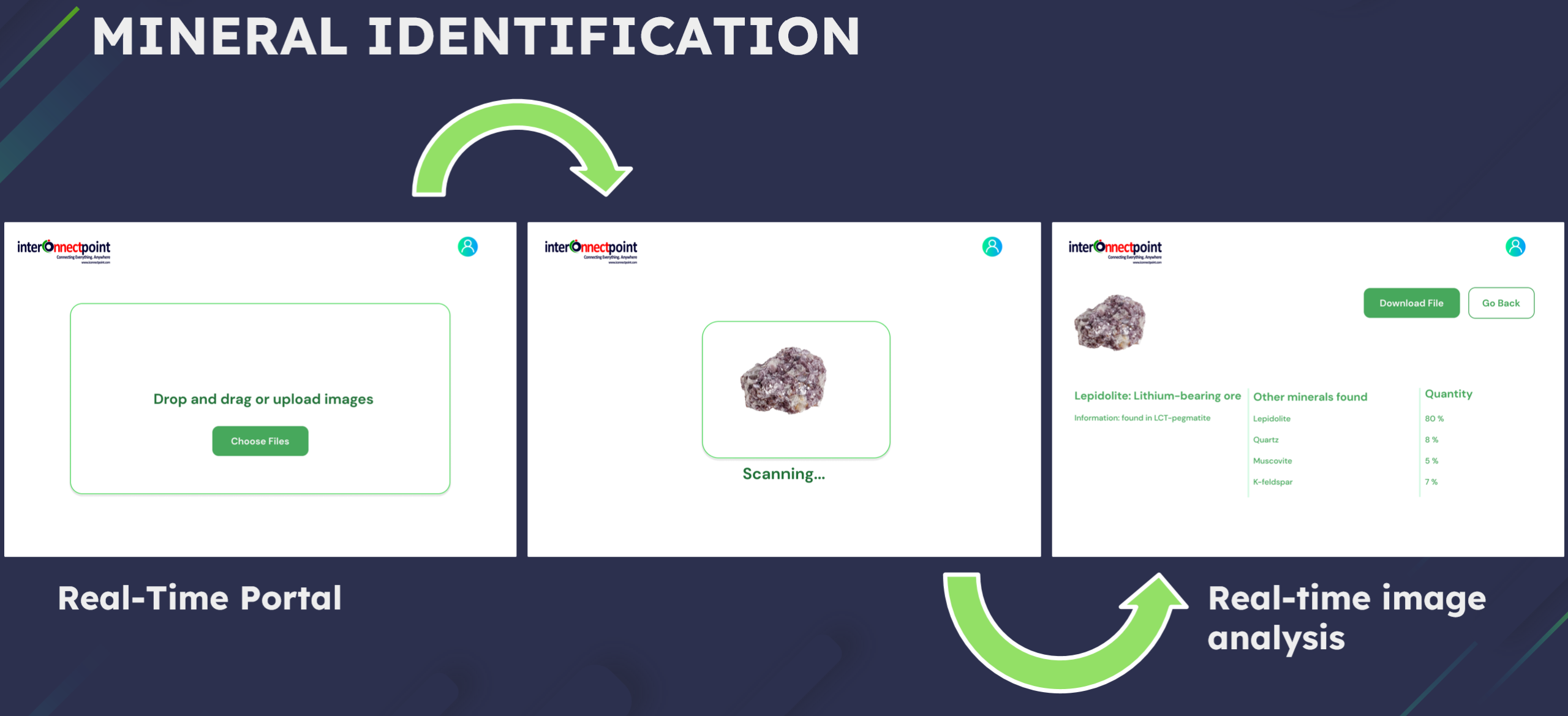
ICP deploys ruggedized edge sensors, long-range telemetry, and custom AI models directly to field rig sites and core sheds, enabling continuous physical and chemical characterization in real time.
┌────────────────────────────────────────────────────────────────────────┐
│                   ICP Mineral Exploration Pipeline                      │
├────────────────────────────────────────────────────────────────────────┤
│  [ Hyper-Spectral Probes ] ──> [ Edge Compute Node ] ──> [ AI Engine ] │
│  • Surface & Drill Core      • LoRaWAN® / Satellite    • Mineral Grade │
│  • Multi-Wavelength Sensing  • Low-Power Off-Grid      • Structural 3D │
└────────────────────────────────────────────────────────────────────────┘
Key Technical Capabilities
1. Hyper-Spectral Probes & Electroformed Contact Sensors
-
High-resolution optical, infrared, and contact sensing heads manufactured via proprietary electroforming and precision etching.
-
Capable of detecting subtle mineral alteration zones, vein structures, and lithological transitions invisible to the naked eye.
-
Ruggedized IP67 housing built to withstand field conditions, mud, and dust.
2. AI-Driven Core-Logging & Mineral Identification
-
Computer vision and deep learning models trained to classify lithology, alteration intensity, and mineral assemblages automatically.
-
Real-time estimation of ore boundaries and structural features as drill cores are processed in the core shed.
-
Cross-validation against historical laboratory assays to continuously refine local field predictive models.
3. Long-Range Off-Grid Telemetry
-
Custom LoRa® RF modules transmit field sensor data over distances of up to 100 km to central exploration camps.
-
Battery-optimized edge nodes powered by Wake-on-Radio (WoR) protocols for multi-year remote deployment across unmapped concessions.
-
Seamless satellite and cellular fallback gateways for instant sync to cloud geospatial GIS platforms.
Key Industry Applications
| Application | Technology Deployed | Primary Value Delivered |
| Drill Core & RC Chip Logging | Hyper-spectral contact probes + Computer Vision AI | 50% faster core-logging with automated, repeatable lithological classification. |
| Field Outcrop Mapping | Portable surface probes + LoRaWAN® GPS telemetry | Instant geological vectoring in remote greenfield exploration blocks. |
| Environmental Baseline Tracking | Outdoor weather-resistant humidity, temp & gas probes | Continuous monitoring of acid rock drainage risks and field weather conditions. |
| Concession Telemetry Networks | Ultra-long range LoRa® gateways & edge nodes | Centralized, real-time data flow across vast remote exploration leases. |